Top Gear calls it the World's Best Road possibly, World's Best Road Trip. That is how the Transfăgărășan Road is described on google.
Transfăgărășan (known as the National Road 7C) is a road across the Făgăraș Moutains linking Transylvania to the rest of Romania which climbs to an altitude of 2,042 metres (6,699 ft) and it is a scenic and beautiful and also a very difficult drive.
Upon realizing that this is only two hours away from Bucharest, we decided one October morning to take advantage of the a few days beautiful fall weather and go there for the weekend, especially since it was a good opportunity to see the mesmerizing colors of the fall foliage.
Keep in mind that the road is closed from November 1st to June the 30th each year, and for the rest of the year from 20:00 to 8:00 o'clock every day, as the driving conditions become dangerous at night.
This weekend trip was a combo, because there are a few other places to see on the way just right for spending a relaxing weekend with familty and/or friends:
- The Transfăgărășan Road itself (the southern portion to be more specific) is a winding road with scenic views of forests, mountain tops and glacial valleys.
- The Vidraru Dam - artificial dam built in the 1960s is right on the Transfăgărășan Road and a good firt stop
- Bâlea Lake - is the top point of the Transfăgărășan Road, and the beginning of the descent into Transylvania. Very nice glacial lake here with lots of touristy amenities.
- Poenari Castle - (one) of the true residences of Vlad the Impaler a.k.a. Dracula. Located right before the ascent to the Vidraru Dam, but a 30 minute hike on the top of a hill (thunder sounds and evil laughs not included :-) ).
- Curtea de Argeș Monastery - could as well be the first stop on the way to Bâlea Lake or the last stop on the drive back to Bucharest. It is the a monastery buildt in the 1600s, which houses the Royal graves of the first two kings of Romania.
The drive is an easy one - 1 hour tops from Bucharest to Pitești via the A1 highway and then another hour from Pitești to the Vidraru Dam, the first stop on the weekend trip.
Beware that from the Vidraru Dam to the Bâlea Lake the drive is about 1 1/2 hours.
First Stop of the Day - Vidraru Dam
About 1 hour and 30 minutes into the trip will reach the village of Arefu.
As as side note, Arefu is a place where there are a few good options for staying overnight, with decent quality and affordable prices. The higher up on Transfăgărășan you go the more expensive the accommodations.
The drive up the moutain begins here. After a 15 minute scenic steep drive through canyons and viaducts you will reach Vidraru Dam (the Transfăgărășan crosses it).
You can park on eiher sides of the dam. Plenty of things to admire here: the view towards the lake, the view of the dam looking downstream as well as the statue of Prometheus (the Greek god who stole the fire).
I tried looking down the dam, but I was so terrified that afterwards I walked on the dam on the center divide of the road :-) lol.
There is a viewing deck which allows for even better views. I will spend an hour maximum here.
 |
| Transfăgărășan Road - Vidraru Dam |
 |
| Transfăgărășan Road - Vidraru Dam - Looking 166 meters down (gotta have the stocmatch for this) |
 |
| Transfăgărășan Road - Vidraru Dam |
 |
| Transfăgărășan Road - Vidraru Dam - the Observation Deck to the Right |
 |
| Transfăgărășan Road - Vidraru Dam - Statue of Prometheus |
Ascent to Bâlea Lake
From Vidraru Dam, the drive to the Bâlea Lake is another hour and 30 minutes. The road is winding with lots of curves whcih turn into hairpin turns after the road goes past the edge of the Vidraru Lake.
Keep in mind that past Piscu Negru (20 minutes from the edge of the Vidraru Lake) the road is closed from November 1st to June the 30th each year, and for the rest of the year from 20:00 to 8:00 o'clock every day, as the driving conditions become dangerous at night especially since there are no fences on the edge of the road.
Piscu Negru is the midway between Vidraru Dam and the Bâlea Lake. It is the starting point for a few medium/difficult, but awesome as I heard, hiking trails including the one leading up the Negoiu Peak, Romania's second tallest peak at 2.535 meters.
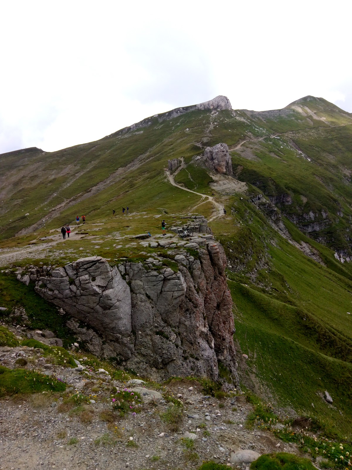
Past Piscu Negru the driving scenery get beautiful - you driving at an altitude of around 2.000 meters with mountain peak surrounding you - and the driving gets difficult - easy to get caught into admiring the views, no road fences for the most part, and a very steep ascent.
The ascent ends with the 800 meters tunnel to Bâlea Lake at an altidtude of 2.000 meters.
 |
| Transfăgărășan Road - Valea Caprei glacial valley ahead |
 |
| Transfăgărășan Road - the uppermost portion with the entry into the tunnel |
 |
| Transfăgărășan Road - the uppermost portion |
 |
| Transfăgărășan Road - the uppermost portion - no fence on the road |
Bâlea Lake
Once out of the Bâlea tunnel the road leads into the Bâlea glacial caldera. It is surrounded by peaks 2.400+ meters high and in the middle of it lies the Bâlea Lake, a glacial lake.
The lake crystal clear and worth admiring for a few minutes. Also, the quiet is deafening. I haven't been to such a quiet place since I have been to the Monument Valley in Arizona long long time ago.
The are two cabins open year roud here and an ice hotel open during the winter. There are also plenty of food and souvernir stalls.
Keep in mind that this place is touristy, plenty of people, but given the sheer size, it will not feel crowded.
 |
| Transfăgărășan Road - the old Bâlea Cabin |
 |
| Transfăgărășan Road - Bâlea Lake |
 |
| Transfăgărășan Road - the old Bâlea Cabin |
 |
| Transfăgărășan Road - Bâlea Lake |
 |
| Transfăgărășan Road - Bâlea Lake |
There also plenty hiking trails starting here, leading to the mountain peaks around the Bâlea Lake, so it is a good starting point for planning full weekend hikes.
 |
| Transfăgărășan Road - Bâlea Lake an the surrounding peaks |
Poenari Castle
I saved this for last, but it definitely last but not least.
Poenari Castle is located in the village of Arefu, perched high up on a hill and accessible from the Transfăgărășan Road via 1.480 concrete steps.
Buildt around 1453, right around the time when the Spaniards were setting foot in the Americas, it was one of the actual residences for Vlad the Impaler a.k.a. Count Dracula, and it is the location the inspired the novel of the same name by Bram Stoker.
The hike up was spectacular for us given the fall season with all the red, yellow, orange and green typical of this season. It only took us about 30 minutes, with two kids, so without kids and good physical condition it can probably be done in 15 minutes.
 |
| Transfăgărășan Road - Stairs leading up the Poenari Castle |
|
Once up you can admire the beautiful scenery and the ruins of the castle, a portion of which collapsed into the valley at the north. While the size of this former fortress is not necessarily impressive, its location is. It is only accessible by foot, which got me wondering how difficult it would have been to build and access it in the past.
 |
| Transfăgărășan Road - Poenari Castle |
 |
| Transfăgărășan Road - Inside the ruins of the Poenari Castle |
 |
| Transfăgărășan Road - Poenari Castle - some kitschy stuff |
 |
| Transfăgărășan Road - Inside the ruins of the Poenari Castle |
 |
| Transfăgărășan Road - Poenari Castle - looking down towards the Vidraru Dam |
Curtea de Argeș Monastery
When travelling on the Transfăgărășan from Bucharest, one must stop to see the Curtea de Argeș Monastery. It resembles a very large and elaborate mausoleum, and was built in the Byzantine architectural style, with Moorish arabesques finalized in 1517.
It is the burial place of the first two kings of modern Romania (Carol I and Ferdinand I) and their spouses.
There is even a legend about this place, Legend of Manole, the builder of the mondastery, who allegedly had to bury his wife Ana alive into the building for it to stop falling apart every night.
Worth speding a hour here.
 |
| Curtea de Argeș Monastery |
 |
| Curtea de Argeș Monastery |
 |
| Curtea de Argeș Monastery - the tumbs of the Ferdinand I and Queen Mary - the second king of Romania |
We have definitely enjoyed our combo trip to Bâlea Lake via the Transfăgărășan and I hope you will too.


